Showing posts with label Archaeology. Show all posts

The Only Green-faced Terracotta Warrior Unearthed

green-faced terra cotta warrior

From Xinhuanet

A terracotta warrior with a green face will be shown in the newly revamped Shaanxi History Museum. The terracotta warrior is the only green-faced warrior out of over 1,500 terracotta warriors unearthed so far. The warrior was put in the showcase at the Shaanxi History Museum in Xi'an city of Shaanxi Province on Monday, Dec. 24, 2007.

#Tags: , , ,

Mummified Dinosaur With Clear Remains of Scales Found in North Dakota

Mummified Dinosaur photo

Fossilized hadrosaur Dakota skin picture (Tyler Larson/National Geographic)

The partially mummified hadrosaur [wiki], dubbed Dakota, were found in 2000 by Tyler Lyson, then a 17-year-old boy, on his uncle's ranch in North Dakota.

The creature is fossilized, with the skin and bone turned to stone. But unlike most dinosaur fossils, tissues are preserved as well.

Scientists believed the Dakota hadrosaur should be the most complete dinosaur ever found, with intact skin where clear remains of scales were visible.

"This is not a skin impression. This is fossilized skin," paleontologist Phil Manning of the University of Manchester said. "When you run your hands over this dinosaur's skin, this is the closest you are going to get to touching a real dinosaur, ever." Source: Reuters

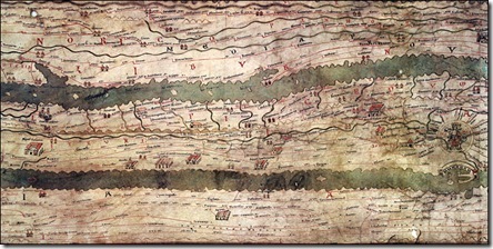
Tabula Peutingeriana, aka Ancient Roman Road Map, Unveiled

Tabula Peutingeriana, Ancient Roman Road Map 

Ancient Roman Road Map: Tabula Peutingeriana (large version)

Tabula Peutingeriana, made in the Middle Ages, is the only surviving copy of a road map from the late Roman Empire. It dates from the late 12th or the early 13th century and was made in Southern Germany or Austria.

The nearly-7-metre-long parchment scroll shows the network of main Roman roads from Spain to India.

At first sight, it looks very unlike a modern map.

Both the landmass and the seas have been stretched and flattened. The Mediterranean has been reduced to a thin strip of water, more like a river than a sea.

Instead of being oriented from north to south, the map, which is only 34 centimetres wide, works from west to east.

At the centre of the Tabula Peutingeriana is Rome. The city, represented by a crowned figure on a throne, has numerous roads leading to and from the metropolis. Some, such as the Via Appia and the Via Aurelia, still exist today.

The Tabula Peutingeriana, one of the Austrian National Library's greatest treasures, is normally never shown to the public and has been on display for only one day to celebrate its inclusion in Unesco's Memory of the World Register on 26 November 2007. Source: BBC Tags: , , ,