
Ivan Morrison's iGoogle and Windows XP Tattoo
First Moon Surface Picture by China's Chang-E 1 Lunar Probe
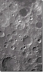
The black and white picture showing rough surface scattered with big or small pits was made public at a gala ceremony in Beijing Aerospace Control Center on November 26 by Premier Wen Jiabao, who hailed it as a major step in "the Chinese race's 1,000-year-old dream" of exploring the moon.
Wen asserted in a passionate and inspiring speech on Monday that China has joined the select group of world powers with the capabilities to engage in deep-space exploration.
The success, he said not only manifested China's rising national strength and technical innovation capability but also elevated the country's international status and cemented national cohesion.
"It showcases eloquently that the Chinese people have the will, the ambition and the capability to compose more shining new chapters while ascending the science and technology summit," Wen said.
Citing a letter from an overseas Chinese, Wen said that the farther the China-made satellite flew, the higher would the overseas Chinese hold their heads.
The area covered by the picture, about 460 km in length and 280 km in width--- about half the size of the United Kingdom, is within a location of 70 to 54 degrees south latitude and 83 to 57 degrees east longitude. Source: Chinadaily & CNN-IBN Tags:
Tabula Peutingeriana, aka Ancient Roman Road Map, Unveiled
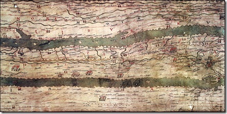
Ancient Roman Road Map: Tabula Peutingeriana (large version)
Tabula Peutingeriana, made in the Middle Ages, is the only surviving copy of a road map from the late Roman Empire. It dates from the late 12th or the early 13th century and was made in Southern Germany or Austria.
The nearly-7-metre-long parchment scroll shows the network of main Roman roads from Spain to India.
At first sight, it looks very unlike a modern map.
Both the landmass and the seas have been stretched and flattened. The Mediterranean has been reduced to a thin strip of water, more like a river than a sea.
Instead of being oriented from north to south, the map, which is only 34 centimetres wide, works from west to east.
At the centre of the Tabula Peutingeriana is Rome. The city, represented by a crowned figure on a throne, has numerous roads leading to and from the metropolis. Some, such as the Via Appia and the Via Aurelia, still exist today.
The Tabula Peutingeriana, one of the Austrian National Library's greatest treasures, is normally never shown to the public and has been on display for only one day to celebrate its inclusion in Unesco's Memory of the World Register on 26 November 2007. Source: BBC Tags:
Subscribe to:
Posts (Atom)