Ancient Roman Road Map: Tabula Peutingeriana (large version)
Tabula Peutingeriana, made in the Middle Ages, is the only surviving copy of a road map from the late Roman Empire. It dates from the late 12th or the early 13th century and was made in Southern Germany or Austria.
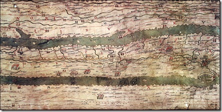
The nearly-7-metre-long parchment scroll shows the network of main Roman roads from Spain to India.
At first sight, it looks very unlike a modern map.
Both the landmass and the seas have been stretched and flattened. The Mediterranean has been reduced to a thin strip of water, more like a river than a sea.
Instead of being oriented from north to south, the map, which is only 34 centimetres wide, works from west to east.
At the centre of the Tabula Peutingeriana is Rome. The city, represented by a crowned figure on a throne, has numerous roads leading to and from the metropolis. Some, such as the Via Appia and the Via Aurelia, still exist today.
The Tabula Peutingeriana, one of the Austrian National Library's greatest treasures, is normally never shown to the public and has been on display for only one day to celebrate its inclusion in Unesco's Memory of the World Register on 26 November 2007. Source: BBC Tags: